I’ve mapped this ride from free parking at the rail trail in Gardiner.
https://ridewithgps.com/routes/37779760
Contact jferguson@medicalwriter.net.


I’ve mapped this ride from free parking at the rail trail in Gardiner.
https://ridewithgps.com/routes/37779760
Contact jferguson@medicalwriter.net.
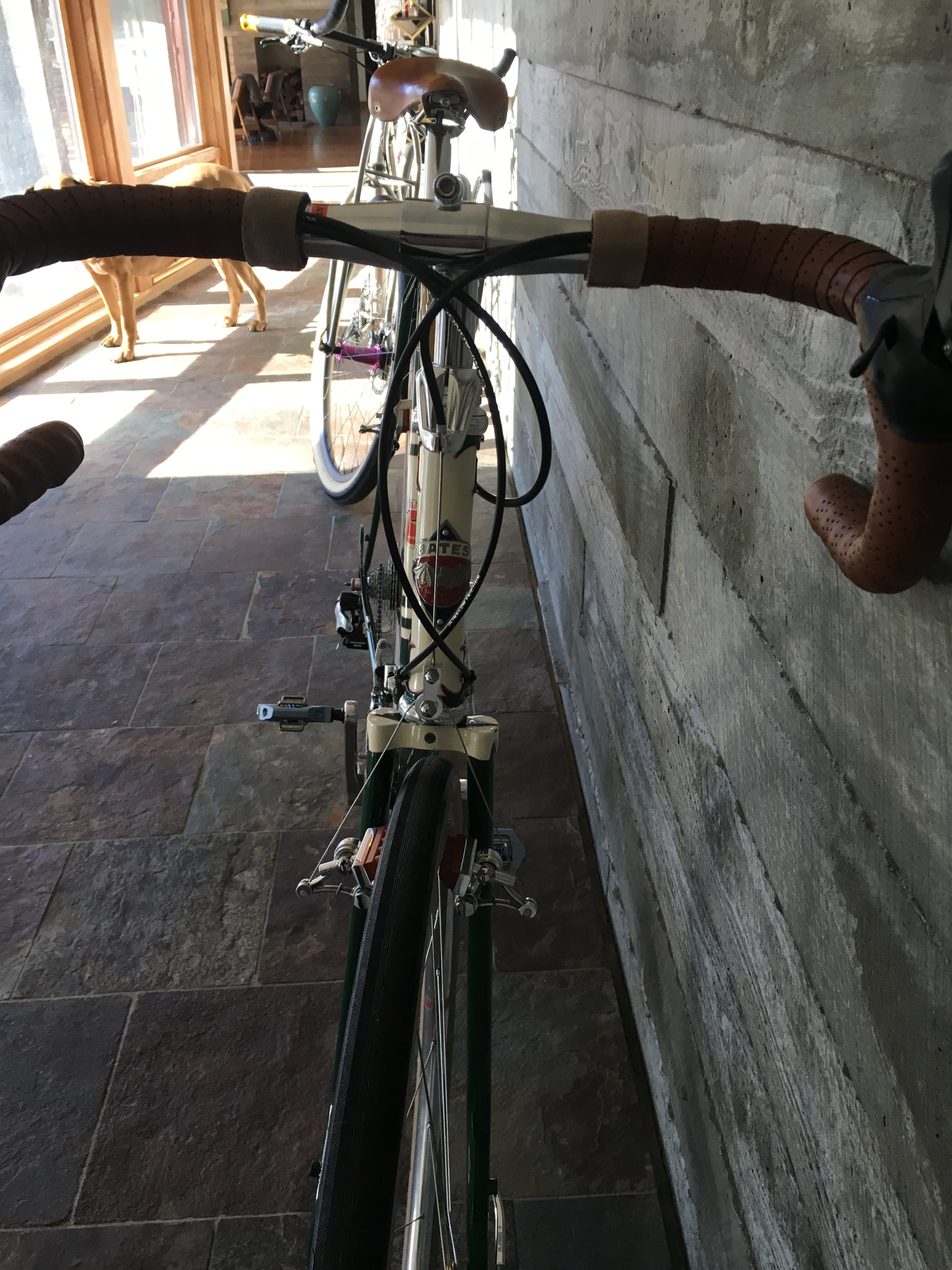
15.7 lbs complete. Stainless steel. Takes up to 32 mm tires, which I’ve learned is more than enough for me. Removing the pump and putting some lightweight wheels on would drop this well below 15–remarkable for a steel bike!
This is my third English in the last 12(?) years. The first was a road bike, which I still adore and ride almost daily. The second was probably one of the very first road bikes built for 650B. Some day I will have that one updated with hydraulic discs and modern components, which didn’t exist when we built the bike. This one is halfway between the two, and likely the one I’ll ride most.


Many years ago, I posted a picture of this frame. It’s a 1960 Bates.
I bought it in London circa 2007. It was a sad, rattle-canned mess. I dropped it off at Argo, a shop that specializes in painting bicycles in the UK. Two years later, they still hadn’t completed it, so I out of frustration, I had them send it directly to Brian Bayliss in California. He had it for…many years and then, sadly, he passed away. Several years after that, Joe Bell contacted me, as he was going through Brian’s estate. He sent it to me for shipping cost + a 12-pack of fine beer (he didn’t insist on the beer, I did–it was the least I could do!) So I finally got my frame back!
I made the decision to use modern components. The folks at Bicycle Depot in New Paltz built this up for me. I was sure that there was going to be some weird things that would interfere with my plans, but other than the dropout screws, everything worked quite nicely. Still looking for some dropout screws that will fit.
I haven’t weighed it, but just hefting it, it doesn’t seem like much more than 20 lbs, maybe even a little less. I’ve only ridden it around the block, and not even in proper shoes, but it rides exactly like a modern steel bike. The bars need to come down another couple centimeters, but the bike otherwise rides like it was built for me.
I’m agnostic about bike materials–I’ve had titanium, carbon, steel, aluminum. But steel really is real…I doubt there will be many 2019 carbon bikes that are still rideable in 2079!


Hi!
Been a while. So long, in fact, that I forgot how to start a post on Word Press.
Just a note that I’m still here. I’ll have some reviews for you shortly and maybe even some bicycle-related content.
If you’re here to read about, you know, bikes: go to the month-by-month menu to the right (if you’re on a desktop at least) and work your way back from May 2015. Yes, it has been that long since I’ve routinely posted cycling-related content other than a review here and there. I have no idea why or how this site is still getting hundreds of views a day?
Even better, if this is the first time you’re here, start at the beginning and work your way forward. Everything is still relevant if you’re planning to ride up here. Except for the fact that they paved over all of the nice dirt in the Olivebridge area. Which I suppose is good news for some of you roadies!
John
So…I’m back on the bike full time, after almost a year off because of the neck injury. I have adventures to report!
In the meantime, I wanted to show you my first fully executed furniture design of the many I have drawn out.
I designed the piece and produced it in collaboration with Pascal Knapp, a sculptor and expert metal worker, and John Moore, an amazing woodworker. We now have templates and process in place if anyone wants something similar.
jferguson@medicalwriter.net


Hi everyone,
I’ve been ignoring the blog recently. Mostly because my rides have been strictly for exercise–no real adventures other than a couple of trips over the ridge (which actually wouldn’t count as an adventure in any other year!) All my time is spent hiking right now, both because of the new dog and because I do not want to aggravate my neck injury.
So…if you have a story you’d like to tell, preferably with lots of pictures and a link to GPS (RideWithGPS preferred), please feel free to submit. Any ride in the Catskills, surrounding area, or Dutchess and Columbia.
All submissions will be posted, although I reserve the right to edit. E-mail me here.
Here’s Shay, my new Ridgeback and the cause of all the hiking:

…and yes, I was actually taking a picture of my new lamps. Shay moves around so much that it’s difficult to get a good awake picture, so this is the best I have right now. You’ll be the first to see it when I manage to capture one.
John
Still riding! Got a new dog, so my exercise time has been tilted more toward hiking and running. She’s very high energy.
This is the magic lasagna recipe from the 1967 edition of “The Cooking of Italy.” I read over and over on cooking sites that this was the best lasagna ever, but as far as I know, this is the first time it is appearing online, as I’ve been unable to find it anywhere else.
So I went to Abe Books and bought the book from ’67, scanned it, text recognized it, and here it is. The book is long out of print, so I hope the lasagna copyright nazis don’t come after me for this.
It is the most amazing thing you will ever eat. I mean come on, chicken liver, smoked ham, ground round, and ground pork?
You’re welcome in advance. If you have modifications or additional guidance, please feel free to leave your thoughts in the comments.
UPDATE:
12/30/2019–I added some headings to make the original recipe, which was poorly written, less confusing. Also, you may want to read the comments first before diving in, there’s some good guidance from much better cooks than me.
Ragu Bolognese
To make about 2 1/2 cups
1/4 pound smoked ham, coarsely chopped (about 1 cup)
1 cup coarsely chopped onions
1/4 cup coarsely chopped carrots
1/2 cup coarsely chopped celery
4 tablespoons butter
2 tablespoons olive oil
3/4 pound round steak, ground twice
1/4 pound lean pork, ground twice
1/2 cup dry white wine
2 cups beef stock, fresh or canned
2 tablespoons tomato paste
1/2 pound chicken livers
1 cup heavy cream
Pinch of ground nutmeg
Salt
Freshly ground black pepper
Combine the chopped ham, onions, carrots and celery on a cutting board, and chop them together into very small pieces. (This mixture is called a battuto, which when cooked becomes a soffritto.)
Melt 2 tablespoons of the butter over moderate heat in a heavy, 10- to 12-inch skillet. When the foam subsides, add the battuto and cook, stirring frequently, for about 10 minutes, or until it is lightly browned. With a rubber spatula, transfer the soffritto to a heavy 3- to 4-quart saucepan. Heat 2 tablespoons of olive oil in the same skillet, and in it lightly brown the ground round steak and pork over moderate heat, stirring the meat constantly to break up any lumps. Then pour in the wine, increase the heat, and boil briskly, still stirring constantly, until almost all of the liquid in the skillet has cooked away. Add the meat to the soffritto in the saucepan, and stir in the stock and tomato paste. Bring to a boil over high heat, then reduce the heat and simmer, partially covered, for 45 minutes, stirring occasionally. Meanwhile, over high heat melt 2 more tablespoons of butter in the original skillet, and when the foam subsides, add the chicken livers. Cook them for 3 or 4 minutes, or until they are firm and lightly browned. Chop the chicken livers into small dice, set them aside, and add them to the sauce 10 minutes before it is done. A few minutes before serving, stir in the cream and let it heat through. Taste the ragu and season it with nutmeg, salt, and pepper. Serve the ragu on pasta or, without the cream, use it in lasagna pasticciate.
Lasagne Pasticciate
To serve 6 to 8
LASAGNE
6 to 8 quarts water
1 tablespoon salt
1/2 pound lasagne
Preheat the oven to 350°. Generously butter the bottom and sides of a 9-by-12-by-3-inch serving casserole or baking dish. In a large soup pot or kettle, bring the water and salt to a bubbling boil over high heat. Add the lasagne, stirring gently for a few moments with a wooden fork to be sure the strips do not stick to one another. Boil over high heat, stirring occasionally, until the lasagne is tender, but still al dente-the time may vary between 10 and 25 minutes, depending on whether you use homemade or commercial lasagne. Set the pot under cold running water for a few moments to cool the pasta. Then lift out the strips and spread them side by side on paper towels to drain.
BESCIAMELLA FOR LASAGNE
3 tablespoons butter
6 tablespoons flour
2 cups milk
1 cup heavy cream
Pinch of ground nutmeg
1 teaspoon salt
In a heavy 2-to-3-quart saucepan, melt the butter over moderate heat and stir in the flour. Remove the pan from the heat and pour in the milk and cream all at once, beating with a wire whisk until the flour is partially dissolved. Return the pan to high heat and cook, stirring constantly with the whisk. When the sauce comes to a boil and
thickens into a smooth cream, reduce the heat and simmer, still stirring, for 2 or 3 minutes. Remove from the heat and season with nutmeg and salt.
LASAGNE ASSEMBLY
Besciamella
The 2 1/2 cups ragu bolognese you made earlier
1/2 cup freshly grated imported Parmesan cheese
Lasagne noodles
Spread a layer of ragu bolognese about 1/4 inch deep evenly over the bottom of the buttered casserole. Spread over it about 1 cup of besciamella. Lay one third of the lasagne on the besciamella, overlapping the strips slightly. Repeat the layers of ragu, besciamella and lasagne two more times, then top with the rest of the ragu and a masking of besciamella. Sprinkle with grated cheese. Bake 30 minutes, or until the sauce is bubbling hot.
It is done.
My friends at Bicycle Depot in New Paltz installed eTap for me. Good decision, they spent a ton of time getting the front to shift right on my very unconventional gearing.
Admission: I have a mountain bike crank and 46/28 ten speed rings from circa 2011–that is to say they are lacking many of the modern conveniences like good shift ramps etc. In any case, they do not get along super well with eTap. Just a note for people who are planning on retrofitting a gravel bike, with gravel gearing, with eTap.
My plan is, ultimately, to get Rotor’s 46/30 “Spiderings” and a Rotor crank to improve shifting. Kind of a bummer to have to get rid of my lovely THM 400-gram crank though. If you want it, you know where to find me.
However, even though the guys at Bicycle Depot were not entirely satisfied with the front shifting, my first words after a ride around the parking lot were “clearly, you guys have higher standards than I do!” It’s still better than mechanical.
Some pictures, I’m going to ride it for real tomorrow, provided my clients give me a minute to get out of the house.
So refreshing to have new bar tape. The old stuff was getting ratty.

Pretty busy up front with levers, Garmin mount, light mount and blips. But only 2 cables! Looks weird.
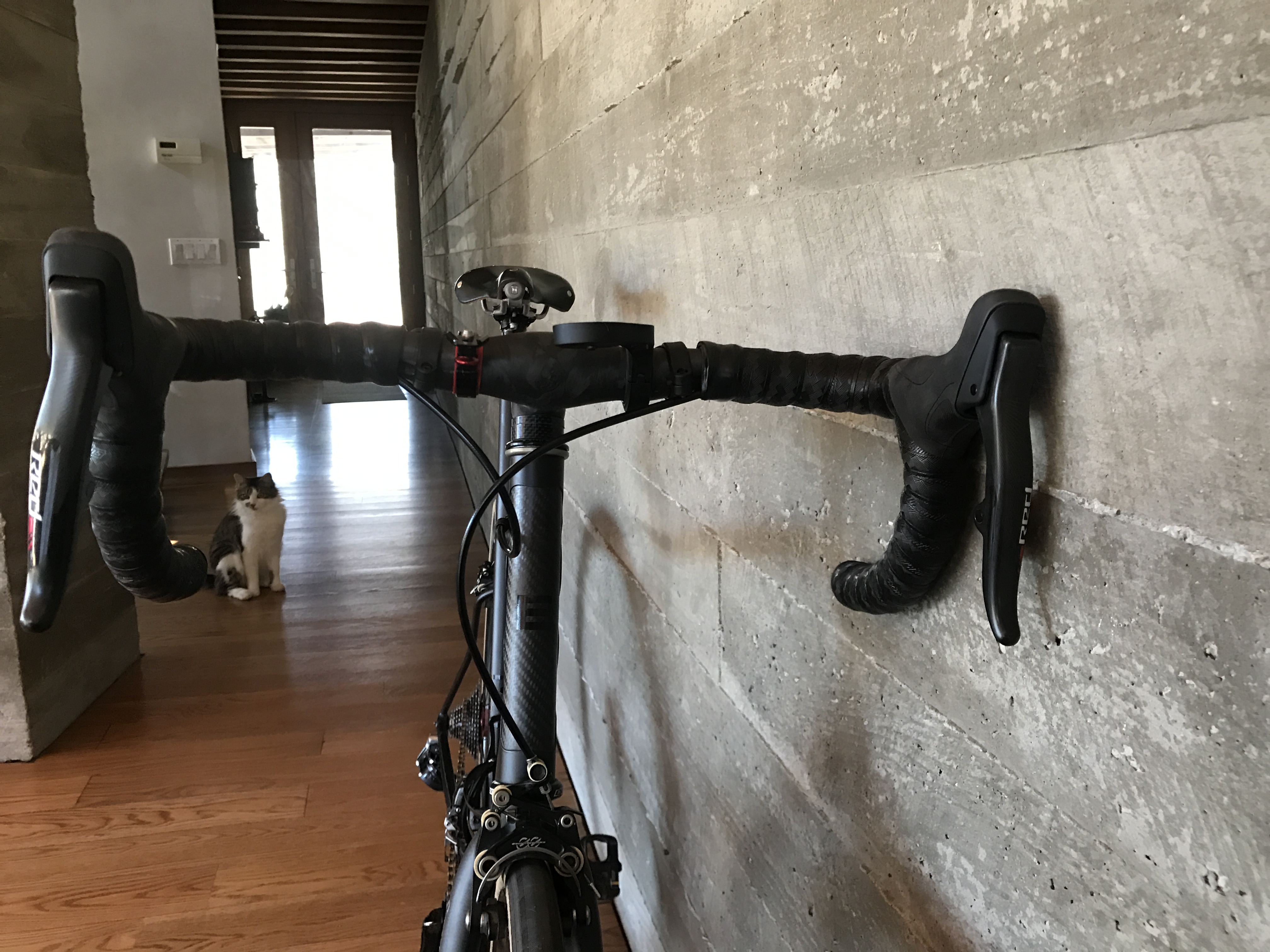
Blips. Mike at Bicycle Depot originally wrapped them under the tape (at my request) and then let me know it looked a little like my handlebars had grown tumors.
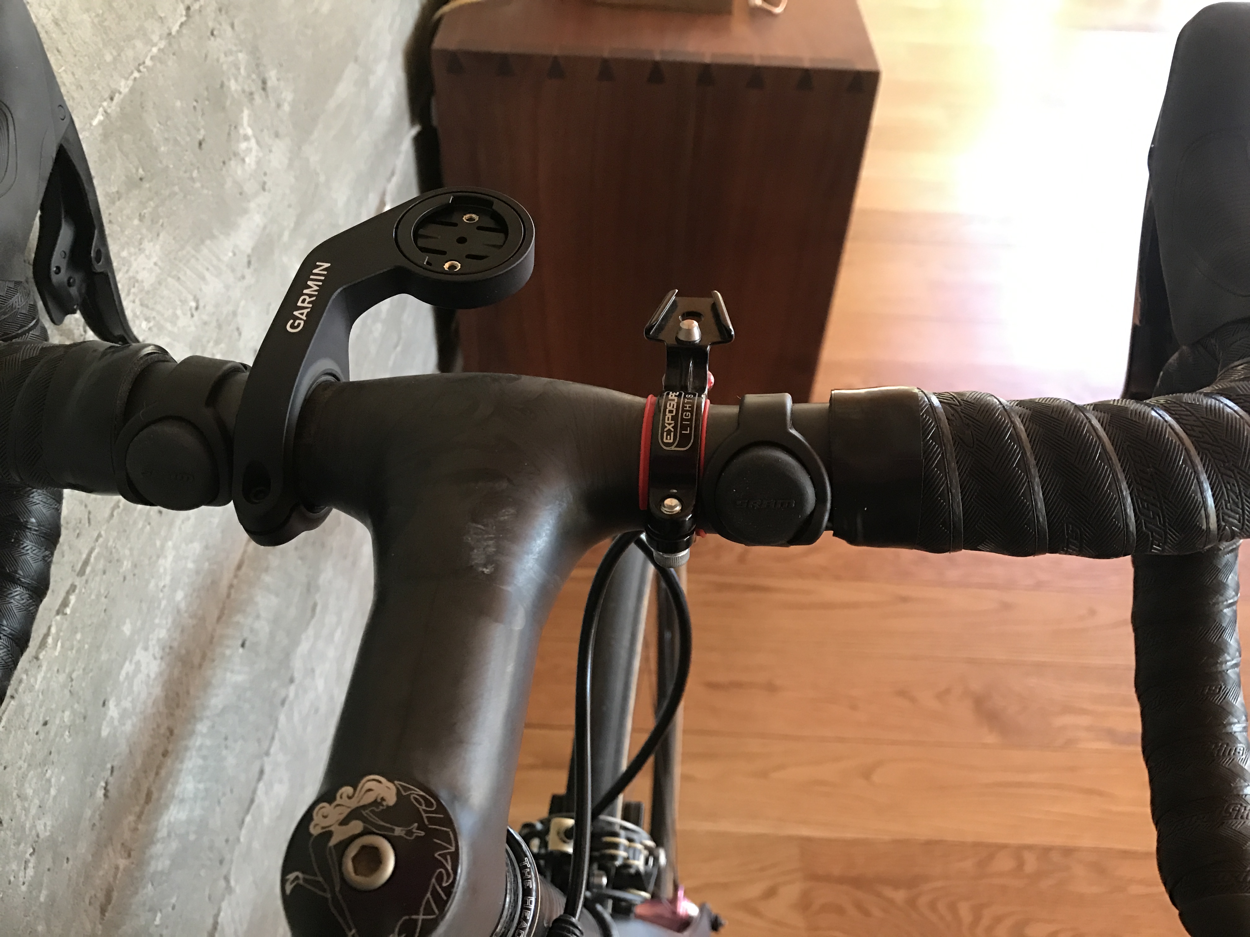
Front derailleur with the aforementioned 10-speed mountain bike rings. Derailleur and old rings do not get along well. I don’t really need 46/28 any more, since…

…I have an 11-32 cassette.

PS: If you’re more interested in routes, a complete library can be found here.
John
Well, I guess I’m back in business. I rode 220 miles on an upright bike in 7 days, a good total at any time of the year! Part of it was an accident of weather–I ended up playing hooky last Friday because it was so nice out, so I got two longish rides in within a single 7-day period. I’ll report on the earlier ride separately.
Good news is that I’m a much stronger rider after 13 weeks of killing myself on a recumbent trainer. Plus my neck appears to be fully healed. Unfortunately, on longer rides I still have to stop every 30 minutes or so for a stretch–some of the muscles in my back become extremely sore, presumably from not being actively used for so long, since I was unable to lift anything (or ride a conventional bike) for 5 months.
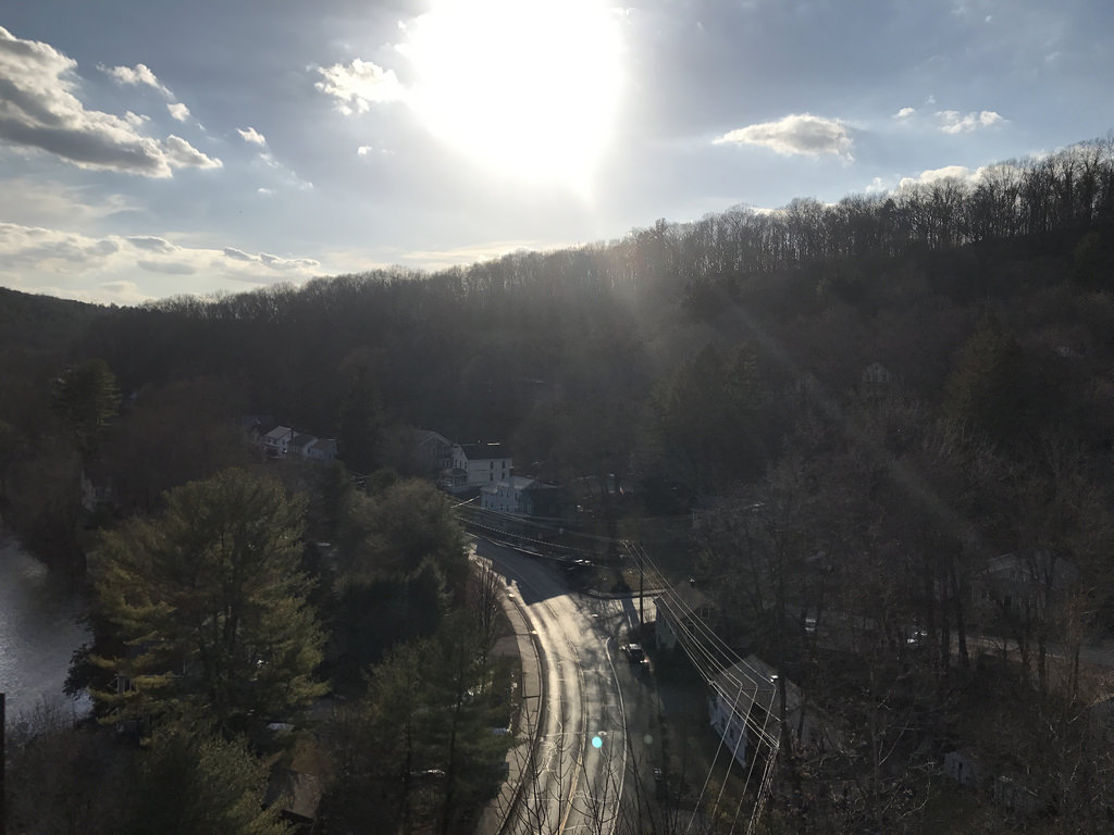
So…last Friday I rode over the ridge, and down into the best riding country in the area. A friend at a local bike shop refers to this area as his “fortress of solitude,” and that it is. In many years of riding up there I have never seen another cyclist, which is crazy because it is gorgeous country. I’m referring, specifically, to the area north of route 209 but south of the Catskills proper.
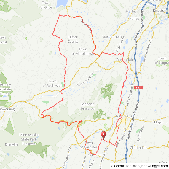
Seriously–if you get a chance, ride up there! If you’re coming from the city, go to the Poughkeepsie stop, ride into New Paltz, and start from there. Here’s the route, with the caveat that there are a few misroutings; if you want a revised route let me know.
Starting from my house south of New Paltz, I headed over to Gardiner, and then up Albany Post to Guilford Road.
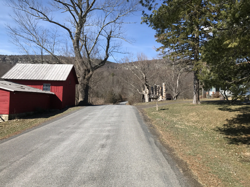
The least pleasant part of this ride is the climb up to 44/55 on Guilford Road. I don’t know why but it kills me every time. I’m totally fine riding all the way up the ridge from there, but there’s something about the way Guilford climbs that is quite painful.
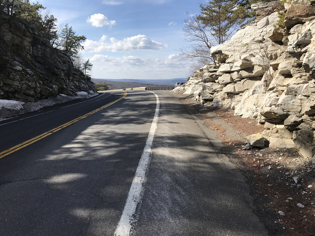
From there, up 44/55. Here’s the traditional hairpin photo.

And then up to the top of the ridge.

Here’s an interesting variation: Laurel Hill Road. It says “no trespassing” on one end, but not the other. I also looked it up and it is plowed by the city, so y’know what? If my tax dollars are paying to keep their road clear, it’s mine to ride on. It’s a short, steep, downhill stretch of well-packed dirt.

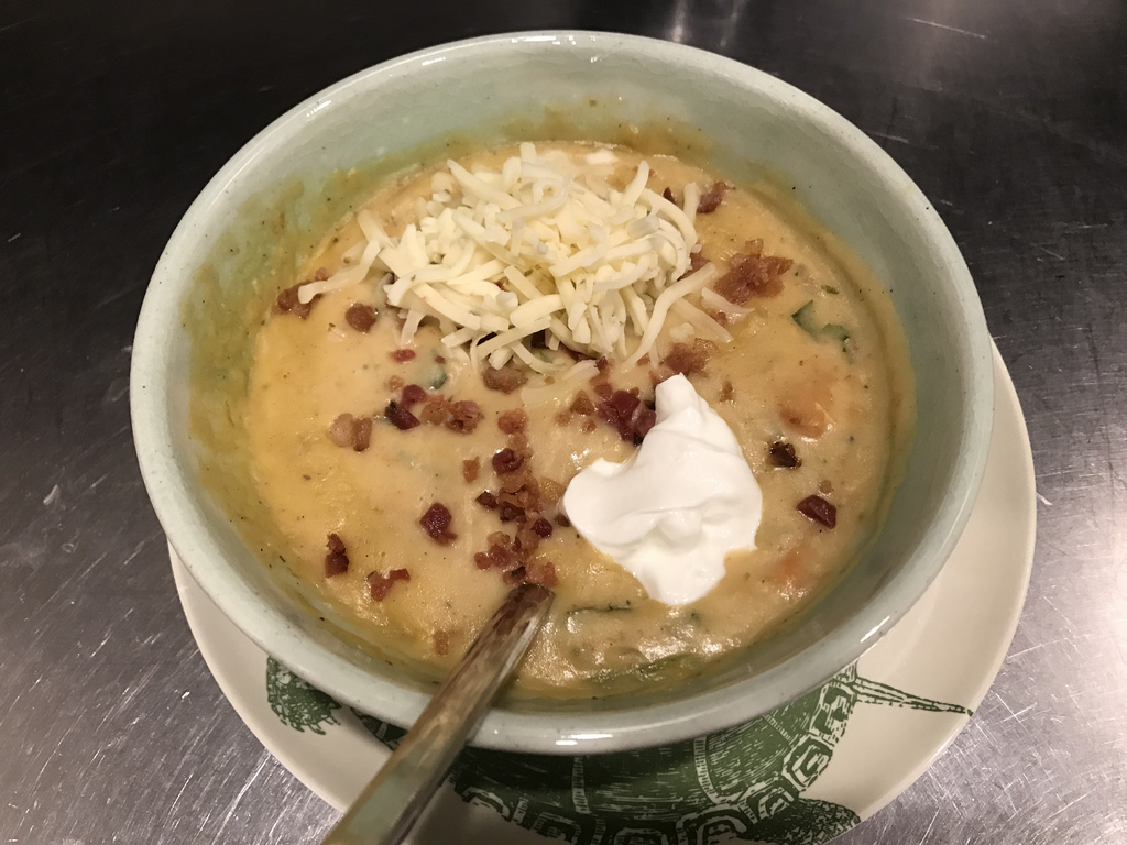
I stopped taking pictures for a while. I crossed over in Rosendale on a brief stretch of trail. Wasn’t much fun as the trail was mostly mud last week–not easy on a skinny-tired road bike. Plus my bike got even filthier. Thankfully, I “accidentally” forgot to wash it before taking it to the bike shop and, um, they took care of the dirty bidness for me.

And that’s it! I made myself some bacon potato soup to recover.
In other news: I’m converting my English 700C to eTap, or rather my local bike shop, Bicycle Depot, is doing the converting for me. “Wait!” you say, Super Record wasn’t good enough for you? The answer is that an electronic groupset is something that I’ve had a hankerin’ for for many years now. I don’t necessarily need it, but I’m a proponent of dead quiet, perfect shifting at all times, and I’m sick of monkeying with mechanical, particularly because my bicycle maintenance skills are poor. I mean, I can do just about everything needed on a bike–and I even built exactly one wheel–but because I don’t have to work on my bikes often, I don’t have a ton of practice so it takes me FOREVER to get most tasks done. Even something as simple as adjusting a derailleur or maintaining a hub. So hopefully electronic will keep me in perfect adjustment all the time.
Last photo with Super Record.

That’s all from me this freezing cold Saturday afternoon. Hoping for some great weather next week for more riding!
John
A brief digression from your regularly scheduled programming.
Those of you who know me know that I do a considerable amount of work on vaccines. In fact, I’d say that it is the work that I’m proudest of, and it is truly a privilege to work with people who develop and train on vaccines (plus they are some of my favorite clients!)
Among all the revolutions that have come over the past century in modern medicine, I think I can safely argue that–at least from a public health standpoint–vaccines have had the greatest impact on disease burden.
Although this post is about the flu shot, just a note: not vaccinating your kids is an antisocial act. In fact, New Paltz is in the middle of a mumps outbreak. Yes, mumps. Nobody should be getting mumps in 2017. Dear dimwits: Jenny McCarthy is not a reliable source for health information.
I got my flu shot last week. I had a day of lethargy that may or may not have been related to the shot, but certainly nothing that impacted my regular activities. If you are afraid of needles, I should note that the needles on most vaccines these days are so fine that you barely feel them. Really!
John
