Author Archives: John Ferguson

Glucosamine and Chondroitin for Knee Pain: What’s the Evidence?

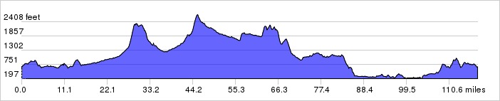
If you’ve been reading along, you know that I’m taking a week or two off from longer rides because of knee pain. I don’t think there’s anything wrong with my fit, it’s clearly from pushing too big a gear up extended 20% grades, plus a saddle collapse that put me almost a centimeter below my usual position. The knee pain really started after a long, long cat 1 climb in the northern Catskills. I’m feeling much better now, but I’m still only going for daily 10-15 mile rides, rather than the 80- to 120-mile rides I prefer. I’ve also, much to my disgust, replaced my Brooks Swallow saddle. I wish something else worked for me, because I don’t like spending $300 on a new saddle every 6000-7000 miles, which amounts to only a year of riding for me—probably less now that I live somewhere that is much more conducive to riding.

So now I have a new found interest in treating and preventing knee pain. My girlfriend, who is a runner, swears by glucosamine/chondroitin supplements, together with krill oil. Being a biomedical scientist, I asked, what’s the evidence?

Before you read this, I want you to keep in mind that I have my own inherent bias, in that I want the supplements to work; also remember that I wrote this post in 15 minutes at 10:00 at night, so it is far from a complete assessment of the current literature!

The GAIT trial was a prospective (meaning planned in advance) 24-month, placebo-controlled study conducted in 572 patients who, at baseline, satisfied criteria for osteoarthritis of the knee. These patients were randomly assigned to several treatments: glucosamine, glucosamine plus chondroitin sulfate, the COX-2 inhibitor celecoxib (a non-steroidal anti-inflammatory drug, like naproxen, with somewhat different properties), or placebo. The primary outcome measure was a 20% decrease in knee pain from baseline to week 24.

Unfortunately, GAIT showed that there were no significant differences among the groups in terms of response: the placebo response rate was 60.1%, whereas the response to glucosamine was only 3.9 percentage points higher, and the response to the combination was 5.3 percentage points higher.

On the other hand, the STOPP trial, which was published in 2009 in the generally high-quality journal Arthritis and Rheumatism, found that there was a significant reduction in joint-space width loss and a significantly more rapid improvement in pain among patients who received chondroitin sulfate, with no safety issues. While I would ordinarily discount a single study, this represents the largest single prospective study of chondroitin in the literature that I am aware of (I’m not writing this for work, so I’m being a little casual about my research). But it’s not much bigger than the previously noted negative trial. Again, this study was conducted in patients with pre-existing, relatively severe osteoarthritis.

The results of these small trials are interesting, but given their small size and the fact that they enrolled patients with osteoarthritis that was fairly significant (and thus, a group that is unlikely to be participating in exercises that stress the knee), they don’t have a lot of relevance for your average active athlete. Another study, conducted in Navy Seals, found that knee osteoarthritis symptoms were relieved in patients who took the active treatment, which in this case included glucosamine, chondroitin, and manganese ascorbate. This study may be the most relevant to the average athlete, as Navy Seals, one would suspect, are reasonably active.

Now, what about meta-analyses? Meta-analyses combine data from multiple trials, and are often considered to be the best evidence for or against a treatment. Unfortunately, we get contradictory results here as well. A recent meta-analysis, published in 2010 in BMJ, assessed the efficacy of glucosamine, chondroitin, and placebo, again in patients with preexisting osteoarthritis, and found no evidence for efficacy in terms of joint-space narrowing or functional/pain outcomes. Again, all of the studies were conducted in patients with pre-existing, relatively severe osteoarthritis. However, several earlier meta-analyses identified clear benefits associated with these supplements

Setting aside the meta-analyses, which could contradict each other for any number of methodologic reasons, why are the results of the STOPP and GAIT studies discordant? I think GAIT was poorly designed and run. First, the GAIT study had an extraordinarily high drop-out rate. Second, the study used an older radiologic technique to assess joint space narrowing. Third, GAIT used a low threshold to identify responders—a threshold so low that it could easily be reached by many patients in the placebo arm, eliminating any chance to identify a significant difference between active treatment and control.

It seems like the evidence is equivocal, as so much is in medicine. So what am I going to do? Neither glucosamine nor chondroitin appear to have significant side effects, so I am going to keep taking them.

John

medicalwriter.net

New Route: The Great Northern Catskills

About 90% of the time, whether I’m riding alone or with a group, we’re following a route that I designed on Ride With GPS. Since the first time I used it, about three years ago, I’ve become well-versed in designing low-traffic, scenic routes that make everyone happy (at least until the 10,000th foot of climbing). So it was refreshing to follow a route designed by someone else, in this case, Doug. I didn’t know what to expect, but it turned out to be a great route. Here’s the route, with full GPS, of course.

Great Northern Catskills

GNC elevation

We started from Doug’s place in Woodstock. You could also start this route from Stone Ridge, Kingston, or any of the surrounding towns. We headed east out of town, and then north on Glasco Turnpike and West Saugerties Road, crossing the dreaded Platte Clove Road on our way to Palenville. As you can see, everything has gone blindingly green.

L1020500_pe

At Palenville, we headed back west on Route 23A and into Catskill Park.

L1020502_pe

L1020507_pe

23A will take you past Kaaterskill Falls (which actually isn’t visible from the road, at least from what I could see). This picture is of Kaaterskill Clove. I should have taken a picture a little earlier, but Doug assured me that there was a good view from this bridge. Well, this is what I got.

L1020508_pe

About here, my GPS died. Permanently. I think the rain on last week’s ride might have been a little too much for it to handle. This will be the third Garmin I’ve been through in five years. Is it too much to ask that a device intended for outdoor use be waterproof? Garmins are just awful…not only the construction, but also the user interface is something straight out of 2002. If there were any choice in the matter I’d use a different device. I have a Garmin 810 coming in the mail.

The ride up to Palenville is nice—it’s full of rolling hills and you can keep up a high speed. But when you turn onto 23A, things get interesting. There is a massive, extended climb up from about 500 feet to 2570 feet, full of twists, turns, scenic views, and waterfalls. You’re basically doing the same climb as Platte Clove, just a few miles north and much more extended. As a side note, this is a genuine Cat 1 climb–one of the few on the east coast. There are lots of climbs that are much, much harder, but this one combines steepness and length in a way that makes it a Cat 1 climb.

L1020509_pe

L1020511_pe

L1020512_pe

L1020513_pe

The morning of the ride, I agonized over what to wear. I didn’t want to dress for rain and cold temperatures, and I almost left the house in nothing more than a jersey, one light underlayer, arm warmers, and shorts. At the last minute, I turned around and put on tights, a winter jersey, and my Castelli Radiation jacket, albeit without the snap-in space blanket liner. When we left Doug’s place in the morning, I was sure that I was going to fry. As it turned out, it was a very good choice, because by the time we got to the top of 23A, it started raining with wind gusts of 20-30 mph and the temperature dropped to the low 40s. On one descent, I actually had to slow down because my hands were going numb.

We continued north in the freezing rain and wind in the high Catskills, passing through a number of tiny towns—Jewett, Ashland, and Red Falls, before rejoining 23A to head south.

L1020514_pe

L1020516_pe

But first, we took a detour up to a diner in Prattsville—a town on a river that was more-or-less completely destroyed during Hurricane Irene. I didn’t take pictures, but the town is still a mess, particularly west of the road next to the river. We arrived too early for the annual farm machinery show, I regret to say.

L1020521

From there, we headed back south on 23A, crossing the river at Lexington to continue on Route 42. Route 42 passes through some beautiful country. Unfortunately, this section of the ride—which was supposed to be easy—was plagued by 20-30 mph headwinds. We barely touched 15 mph, even on downhill segments. Between the climbs and the death march into the wind, I messed up my knee. The wind acted as a blow drier, though, so eventually I dried out.

L1020522_pe

L1020526_pe

After the ride, I looked at my saddle, and I realized that my Brooks Swallow was undergoing its annual irrevocable collapse, which lowered my position by almost a centimeter. Hence the knee pain. Garmin and Brooks should get together to make a leather-covered GPS unit that breaks down after a year of use. If I had any choice in the matter I’d use anything but a Brooks Swallow, but that’s the only saddle that works for me.

A few more pictures of this segment.

L1020527_pe

L1020531_pe

Once we hit 28, Doug and I parted ways. He headed back to Woodstock, and I rode home to Olivebridge. At this point, my knee was really hurting, so I was going slow.

L1020533_pe

I took a break only about 8 miles from home, at my favorite spot on the Ashokan Reservoir. Two teenage girls complimented me on my bike, but in retrospect I think they were being sarcastic, because it (and me) was covered with a thick coating of muck and mud.

L1020534_pe

The last leg was tough, and I actually walked my bike up a little hill near my place because I didn’t want to further stress my knee. When a car passed, I bent over like I was fixing something. So embarrassing.

Although it isn’t really feasible from Poughkeepsie, this route is definitely worth the trip if you can make it out to Woodstock for an overnight. You get a couple great climbs, absolutely gorgeous scenery, and long downhill segments (hopefully you won’t have to battle a headwind). Nice work, Doug!

I’m taking a few days off the bike so my knee can fully recover, and then this week I’m going to do daily 15 or 20 mile rides.I am particularly annoyed because I had planned on doing a 400k in New Jersey this weekend (in fact, I would be finishing it up right about now).

Although the knee pain is probably attributable to the saddle collapse, it also—in part—might be a case of spring knee. I’ve really overdone it the past few weeks, riding well in excess of 200 miles a week. Not a big deal in the flatlands, but when 250 miles means 20,000 feet of climbing or more, it isn’t easy on your body! I’m also strongly considering lowering my gearing considerably—although climbing these hills in 34-27 isn’t a problem aerobically, it is clearly causing undue wear and tear on my joints. Maybe I’ll ask Rob English to put a mountain bike derailleur on the 650B he’s building for me…34-36 would likely cause a lot less stress.

Oh, and some news. I bought a Leica R6.2, so I’m taking photos with gen-u-ine film now. Now I can annoy my riding companions even more with extended stops so I can manually adjust my shutter speed and aperture before snapping a photo!

Leica 6.2Film photos coming to a blog near you soon.

John

medicalwriter.net

Anyone can do it!

I was reading Jan Heine’s excellent blog, Off the Beaten Path, and a comment from Jan struck me:

“We really are just a bunch of middle-aged guys enjoying ourselves. We do have excellent bikes, and we do some focused (and fun) training. Optimizing these factors, plus years of experience, allow us to do things that may seem exceptional. Vélocio said that rides like these are within reach for ordinary people, and I hope we are proving him right.”

It’s true.

I’m not in Jan’s league, but I’m closing in on middle age and I pull off “feats” of endurance every weekend—and sometimes twice weekly—that astonish my friends and my colleagues (my girlfriend is decidedly less impressed, I think she’s sick of hearing me talk about the XXX miles I ride each weekend). And let me tell you, my athletic ability is nothing special, or at least it started out as nothing special.

I get a lot of comments both here and via e-mail, about how “hard core” I am, riding reasonably long distances in all weather. Well, I don’t enjoy suffering the way some people do, and I have no goals on my bike except getting out of the house, into nature, exploring, and enjoying myself. I don’t do any special training. Although I ride three or four 20- to 40-mile rides during the week, all of my rides are for fun. They don’t include intervals, hill repeats, or power measurements. They are more than adequate as preparation for the 80- to 200-mile rides I prefer. Anyone who rides a lot will tell you that 100 miles isn’t a big deal…at all.

If I can do it, anyone can. The first step is to get a decent bike. It doesn’t have to be expensive, but don’t buy it on E-Bay or by mail order. Go to a good shop, explain your intended use, and get them to help you find the right bike. You’d be astonished by the difference it makes. You can also find great bikes on Craigslist; in fact, I found an awesome vintage Trek with high-end Suntour components for one of my assistants for only $300 (with a TA Pro Vis 5 crank and rings, no less, and you know how much those cost).  Try a number of saddles and find one that works for you. Everyone is different. Get some appropriate riding clothes too, it makes a huge difference and enables you to ride in all weather. Everyone resists the jersey and padded shorts when they first start riding, and almost all of them eventually give in.

And that’s about all the advice I have!

John

medicalwriter.net

Cherrytown Road Hike

For various reasons won’t get into here (I’ll be fine!) I took a few days off the bicycle to go for a hike with my girlfriend Margot and the ladies. I have to be active for at least an hour a day, no matter what.

We loaded the dogs into the back of the car, and drove seven quick miles to the start of the trail. Here’s the route, which I supply primarily so you can see the end point and plan your own hike.

route-1771104-map-full

As you approach, you’ll see a sign and a little gravel parking lot. The hike itself is about four or five miles round trip, and I would rate it as relatively easy if you are in reasonable shape. There are some scrambles up loose gravel/rocks on the way to the falls, and some jumping over mini-streams, including one ford on some loose fallen tree trunks.

The Catskills rangers were nice enough to put in a bridge over one of the little streams.

SDIM0314

No, that’s not the Unibomber, that’s Margot, followed by Macs.

SDIM0317

Panda. One of the rare moments where she’s drinking from clear water. They usually just love to lap water out of mud puddles. I don’t know why.

SDIM0322

One of the fords across a little stream. You have to jump from rock to rock, making sure that you don’t twist an ankle. It’s shallow enough to walk through if you want.

SDIM0324

The objective of this hike is to get to this lovely waterfall. I know it has a name, I just can’t recall it right now. (Vernooy Kill Falls–thank you Steve!)

SDIM0326

The dogs always have a blast on this hike. Watch out for ticks, though. Macs transported a few home.

SDIM0340

And the path home….

SDIM0350

Yes, it’s paradise out here. Even after 8 months I can’t believe I live here. I feel like I’m on vacation every time I step out on my front porch. Then a client calls….

Planning a 101-mile ride with Doug shortly. Report to come!

John

medicalwriter.net

A Chariot to Cycling Nirvana

In a past post, I detailed how to get from Poughkeepsie over the Shawngunk Ridge to my immediate area by bike. But what if you want to get right to the good stuff? There are a few options. You could drive up from New York City or New Jersey, or you could take the train to Poughkeepsie and then rent a car (tough to do on weekends, especially since the car rental place isn’t open on Sundays for returns), or you could get a car service to pick you up and drop you off somewhere more pleasant.

Those of you who know me know that I travel a lot. In order to do that, I have a 2-hour car trip to and from Newark airport. We only have one car, so I use a car service (kindly paid for by my clients, thank you). I tried one car service and it was a disaster. Then I found Chariot Airport Transportation/Northeast Transport Services, and they’ve been completely reliable for the 15 trips to and from the airport and the 5 or so trips to and from various meetings in NYC and New Jersey that I’ve made since we moved here in September. Plus, their drivers are great—nothing at all like the gentlemen from Carmel or Delancy!

On my last trip, one of the co-owners, Ryan, drove me to the airport. We got to talking, and I found out that 1) they have SUVs that can accommodate up to two bikes and 2) they have a combination of two vehicles that can accommodate up to ten riders and ten bikes. So, an option would be to take the train to Poughkeepsie, and then have them pick you up and drive you to the start point of your ride. You could either return to Poughkeepsie, or have them pick you up.

I’m not a big fan of driving to ride, but I can totally see where, if you’re coming from the city, you might want to start right at the foothills of the Catskills (for example, Slide Mountain might best be accomplished from a starting point in Shokan or Phoenicia). I recommend Chariot highly if this is what you want to do.

And before you ask, I didn’t get a free ride from them in return for this–I don’t need it since I don’t pay for the trips anyway! It’s just a pleasure to give a plug for a locally owned business that I know is highly reliable, reasonably priced, and a pleasure to deal with.

Their phone number is 845-876-3000, and their website is here.

John

medicalwriter.net

New Route: Ferguson Road (Up and Over the Shawangunk Ridge)

I’ve been trying to arrange a ride with my friend Doug for a while. He is president of the Ultra-Marathon Cycling Association, so—like me—he likes to put in more than a few miles.

A few weeks ago Doug proposed setting aside Wednesdays for rides, and as a fellow member of the self-employed crüe, I agreed. I work almost every day, so it makes no difference to me if we ride on Wednesdays or Saturdays (with the exception of days with scheduled client meetings, travel, or teleconferences, of course).

So, it was with some trepidation that I agreed to a ride. The trepidation was not because of the distance, which wasn’t too long, or because of the climbing, which was significant, but nothing remarkable. It was because of my history with Doug on rides. Let’s summarize:

On my first ride with Doug, he crashed on ice. Luckily Doug is much more durable than me, and he got up and we continued on.

My second ride with Doug (and John S) was marked by freezing rain, deep fog, and a 30 mph headwind. And I bonked.

On my third ride with Doug, I crashed on my hand.

I’m happy to report that nothing bad happened on this ride, so the curse is broken. We rode approximately 77 miles in rain that went from just a sprinkle to torrential and back again all day. At no time did it stop completely. It was awesome, and the route was gorgeous.

Here’s the route, and the GPS is here. We went off course a few times, sometimes deliberately and not so deliberately, adding and subtracting miles.

Ferguson

We began with a high-speed descent from my place into Rosendale. We decided to take the bike path down to the real climbing. Now, I know “bike path” has bad connotations, especially if you live in NYC, but the path here is beautiful dirt. Here’s where we started in Rosendale, right next to the railroad trestle.

L1020466_pe

Did I mention it was raining?

L1020469_pe

I stopped and actually got off my bike to take a picture of this grumpy turtle who was crossing the path as we passed. Edit: My neighbor, Nancy, tells me this is an eastern box turtle. They can live up to 100 years. I wonder how old this guy (or gal) is?

L1020467_pe

Um, did I mention it was raining? We basically rode through a stream.

L1020475_pe

As you can see, the bike path passes through some glorious countryside. It’s really more of a cow path in sections, and it’s a good test for anyone on a road bike with 25 mm tires. To me, this is just as good as a gravel road.

L1020474_pe

You’ll pass over a few trestle bridges on the way down to Gardiner.

L1020471_pe

Now, I’m not afraid to get a little dirty, but fenders may have been a good idea on this ride. On the other hand, it’s possible that fenders would have just gotten jammed up with mud. It was pretty thick in places. At the point this picture was taken, I was as wet as I would have been had I jumped in the river below. My rain pants were soaked through and sagging like a diaper. Fun!

L1020473_pe

We got off the bike path just south of New Paltz, and continued on glorious country roads back over to the Shawangunk ridge.

L1020481_pe

L1020482_pe

L1020483_pe

We stopped briefly for lunch at the Hoot Owl…

L1020485_pe

Where we played darts while waiting for our food. We were worried that they wouldn’t want to seat us inside since we were literally covered head-to-toe in mud (and, in my case, probably a bit o’ horse apple that I failed to avoid) but the bartender said he was unworried, because lots of farmers stop by for a mid-day beer in similar condition.

L1020484

There was an enormous Clydesdale across the street. I’ve never seen one in person. They are enormous–the horse in the foreground, in fact, is a regular-sized horse.

L1020486_pe

After lunch, we continued up and over the ridge.

I had planned this route on the advice of John S, a local and decidedly faster rider than either Doug or I. He told me there was an amazing gravel climb on Ferguson Road. What he didn’t tell me is that you have to be going in a counterclockwise direction to hit the climb. We went the opposite way. It’s my fault that I didn’t investigate further—it’s something I easily could have discerned from inspecting the route more closely.

We climbed Pickle Road, which was steep but nothing to brag about, to Firetower Road. If you see any road named “Firetower” you know that you’re close to the top, and we were.

And here, my friends, is Ferguson Road. No relation.

L1020493_pe

You say you like gravel? Do you like descending 14% to 18% grades in a torrential downpour? If you do, this ride would have been for you. These pictures (which were taken before the road became outright loose gravel) don’t make the road look all that impressive, but trust me, it’s steep, it’s beautiful, and it’s definitely a challenge at speed in the rain.

L1020496_pe

L1020494_pe

…all things considered, I would have much rather gone up it than down!

From there, we continued home via Ellenville, where I forced Doug to stop at McDonalds. I had a giant coke and two apple pies, thereby obliterating any health benefit I got from my ride. My first time at McDonalds since, oh, 2009 or so, and I don’t regret it. Not even a little.

This ride would be a great to do out of Poughkeepsie, picking up the track from New Paltz. Very low traffic, beautiful roads, some dirt, and absolutely glorious scenery. To me (and to Doug) the rain and mud made it even better. I’ve done a lot of rides of reasonable length out here, but this one was exceptional. Thanks Doug!

The end result of our travails:

L1020499_pe

L1020497_pe

Took me a while to clean out those eeBrakes. Good thing they work better than just about any other brake out there, because there’s a lot of crannies to clean up.

Finally, a plug for the UMCA: If you’re interested in riding anything in the century plus range, you should join. It’s cheap and you get a great magazine, access to events and competitions, and other good stuff. I’ve been a member for a while (although, come to think of it, I may need to renew!)

John

medicalwriter.net

Monthly Pet Picture: The Snail Hunter

Just a brief aside from all the cycling related content: My girl Macadamia (Macs).

Snail Hunter (Large)

She recently developed the habit of fishing for snails in our lake. She ferociously chases, attacks, and crushes them, and then devours the meat. No ill effects that I can see, except, perhaps, for cranial gigantism. The thing I don’t understand: such behavior is to be expected from Dogues de Bordeaux, not from Cane Corsos. Thankfully, her vicious behavior is constrained to molluscs, she’s a big giant sweetheart with people and, as I recently found out, with mice. She’s useless for pest control!

Two days off from riding, and then I’m taking a casual 85-mile ride with Doug H. Of course we put all the brutal climbing at the tail end of the ride.

John

medicalwriter.net

New Route: Slide Mountain 117

Slide Mountain: The highest paved pass in the Catskills. At approximately 2700 feet, it isn’t much compared to the Rockies, but the climb up is…special, with extended grades of up to 16% and a few sections where you think you’re done, but really you’re not. Slide Mountain is a tease, but more about that later. This is, incidentally, the second of the eight major climbs I want to complete this year.

Here’s the route. It’s 127 miles, and features several climbs that you won’t forget, followed by significant downhill segments where you can really get flying—I’m talking about 50 mph or more for extended periods.

Slide Mountain

The elevation profile is decidedly exciting. There are two major climbs. The first—which I think is actually more difficult–is on Crump Hill Road. The second is Slide Mountain proper.

ele_profile

The route begins, of course, at my place, and leads quickly to Route 28. Route 28 is a relatively busy road, but the scenery is beautiful, and the shoulder is an entire lane wide. So it’s safe, and as importantly (given the climbing you will do later in the day) it is flat. Don’t be scared by the slow ramp up between miles 15 and 26, it genuinely feels flat.

1 (Large)

2 (Large)

Right around here is where I stopped to answer a work call (yes, on a Saturday). I left my phone on a park bench near Phoenicia, so if you happen to see a scratched up Galaxy III, you know how to reach me! Seriously, though, it was a blessing—I hated that phone because it had no reception in my house. My girlfriend has been happily making and receiving calls with her iPhone, so that’s what I’m going with.

Anyway…Route 28 will lead you to Route 42, which carries you up into the hills and onto Crump Hill Road.

7 (Large)

8 (Large)

I passed a shack that was deteriorating in an appealing manner on my way up.

23 (Large)

12 (Large)

I didn’t take any pictures while I was climbing, for obvious reasons. Slide Mountain is a bitch, let me tell you. There’s a somewhat level area about half way up that makes you think you’re done, but you’re not. Go around the hairpin, and you’ll have another 700 feet of climbing! Don’t make my mistake: I sprinted up the first 500 feet of the climb, thinking it was easy. Then I rounded the bend. Ouch.

Here I am at the top of the climb. Proof.

14 (Large)

After Slide Mountain, you’ll be rewarded with many happy miles of descending on Frost Valley Road, with a only a few bumps to interrupt the bliss.

13 (Large)

18 (Large)

11 (Large)

17 (Large)

I took a detour on Lost Clove Road, thinking that a lost clove would be interesting. It wasn’t (and it turned my 117 mile ride into a 127 mile ride).

9 (Large)

At times, I felt like I was in the Pacific Northwest, because the foliage trends towards evergreens, rather than deciduous trees. This is my favorite bend in the road. Unfortunately, the contrast between the very sunny day and the deep shadows made it difficult to capture a good picture, but if you click on it to see the full size it doesn’t look too bad.

5 (Large)

A substantial segment of Frost Valley Road parallels a good-sized stream. I have never seen water this clear.

22 (Large)

Much to my disappointment, I ran out of camera battery around here. Actually a good thing because I was wasting too much time documenting the route. From here, you ultimately descend into Grahamsville, and then it’s rolling countryside all the way home, with a nice decent on Irish Cape Road into Naponach and dinner (or lunch, if you’re faster than me).

It was an absolutely perfect day, only one of a long succession of perfect days we’re had recently. I highly recommend this route; if you need it shortened up, or a few climbs eliminated, let me know and I’ll gladly redraw it for you. No avoiding Slide Mountain, though!

And finally, an announcement…we’re planning another gentleman’s ride next week, probably 70 or 80 miles. So if you want to try some distance riding in beautiful country at a decidedly non-challenging pace–and you can make it up here next weekend–please contact me. We stop for pictures, for lunch, for dinner, for water bottle refills, and sometimes just because we feel like it. No deadlines except trying to get it done during daylight hours. I won’t say it’s easy because there are some pretty stiff climbs on the route I’m planning, but there will be plenty of opportunities to rest and enjoy the day. Come on up!

John

Medicalwriter.net